Board of Advisors
To ensure excellence in conduct of mission, the management of SharedGeo relies on a volunteer Board of Advisors who help guide development of SharedGeo’s administrative, financial, legal and operational functions. These advisors have included:
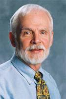
 Dr. William Craig
Dr. Craig is currently the Associate Director Emeritus of the University of Minnesota’s Center for Urban and Regional Affairs (CURA) where he previously served as the principal investigator on numerous CURA projects. He is also an adjunct faculty member of the Master’s Urban and Regional Planning program. He holds a Ph.D. in Geography from the University of Minnesota.
Dr. Craig is a well-known leader in Geographic Information Systems (GIS) and continues to serve on many local, state, and national GIS organizations. His outstanding contributions to GIS have been recognized with numerous awards and honors.
He has been inducted into the URISA GIS Hall of Fame (2009) where he was said to be “one of the pioneers of urban and regional information systems and GIS” and as a Fellow of the University Consortium for Geographic Information Science (2011). He is also the recipient of the Minnesota GIS/LIS Lifetime Achievement Award (1995), MetroGIS Certificate of Appreciation, and the University of Minnesota Academic Staff Award (1998).
Dr. Craig’s impressive list of appointments and contributions includes: President of URISA (1986-87); President of the University Consortium for Geographic Information Science (1997); President of the National States Geographic Information Council (2009-10); Chair the inaugural national GIS/LIS Conference (1988); Chair of the Minnesota Governor’s Council on Geographic Information (1992-93); Chair of the MetroGIS Coordinating Committee (2000-02); member of the Mapping Science Committee of the National Research Council (NRC) of the National Academies (2000-2005); and member of the NRC Committee on Land Parcel Databases (2006-07).
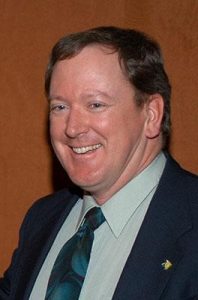
 Brian Huberty
Brian Huberty started his career in the northern forests of Minnesota as an inventory forester, which turned into a career as a remote sensing scientist. Over the last four decades, he has applied remote sensing and geospatial assessment technologies for the Minnesota Department of Natural Resources, Department of the Interior – U.S. Fish & Wildlife Service and Geological Survey, U.S. Department of Agriculture – Forest Service and Natural Resources Conservation Service, and Aerial Image Technology. Prior to retirement from the U.S. Fish and Wildlife Service in September 2019, Mr. Huberty was one of the U.S. government’s most senior environmental remote sensing scientists.
Mr. Huberty has B.S. and M.S. degrees from the University of Minnesota, College of Natural Resources; specializing in geospatial resource inventory systems. He is an American Society for Photogrammetry and Remote Sensing (ASPRS) certified Mapping Scientist – RS130, and previously served as Director of ASPRS’s National Primary Data Acquisition Division, and President of its Western Great Lakes Region. He also has served as Chair of the International Society for Photogrammetry and Remote Sensing’s Technical Commission I, Working Group VI – Airborne Optical Sensor Systems.
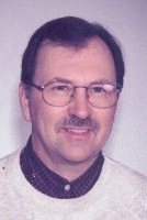
Randall (Randy) Johnson
Prior to his retirement from government service in 2012, Mr. Johnson was founder and visionary leader of MetroGIS, an award-winning, regional geographic information systems initiative serving the seven-county Minneapolis-St. Paul metropolitan area. As one of the nation’s first efforts to coordinate exchange and use of geospatial information across numerous government and administrative boundaries, Mr. Johnson managed an extremely diverse range of responsibilities including: managing strategic and on-going business planning and performance measure activities; providing support to the MetroGIS Policy Board, Coordinating Committee, and special workgroups; coordinating efforts to secure and sustain political support and financing; securing and maintaining key stakeholder participation; securing and administering data and cost sharing agreements; overseeing support for outreach and communications activities; and serving as liaison between MetroGIS and state and national initiatives with similar objectives. Based on his MetroGIS experience, and experiences of other geospatial collaboratives, in 2001 Mr. Johnson published the benchmark report “Lessons from Practice – A Guidebook to Organizing and Sustaining Geodata Collaboratives.”
Mr. Johnson has been recognized by local, national and international GIS communities for his significant contributions. He is recipient of both major awards bestowed by the MN GIS/LIS Consortium; the Polaris Award (2007), and Lifetime Achievement Award (2012). He was also key to MetroGIS being awarded the URISA Exemplary Systems in Government Award (2002). In 2008, Department of the Interior Secretary Dirk Kempthorne appointed Mr. Johnson as a charter member of the National Geospatial Advisory Council, where he served until 2010.
Mr. Johnson holds a Masters in Urban Geography – City Planning Methods, from Southern Illinois University, Edwardsville, and has attended the Seminar for Executive Leadership, Innovations in Governance, at the Harvard John F. Kennedy School of Government.


