SharedGeo Helps Local Girl Scouts Get the Most Out of Maps
 One of the greatest challenges facing public, private, and nonprofit organizations alike is effectively and efficiently identifying potential clients, markets, and/or patrons directly related to the organization’s mission or business. However, Geographic Information Systems (GIS) mapping technologies can greatly simplify this process by organizing data into easy to understand, customizable diagrams and maps.
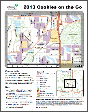
The Girl Scouts of Minnesota and Wisconsin River Valleys have already put GIS mapping technologies to work for them with Cookies on the Go maps, which identify the best neighborhoods for selling cookies, based on which areas are without or have very few Girl Scouts. Cookies on the Go maps, originally created by Alison Slaats with Envision Minnesota, break down census blocks and household density data into easy to understand selling-area maps tailored for use by individual Girl Scouts. Slaats, who currently works at GIS nonprofit, SharedGeo, made over 1600 Cookies on the Go maps for the Girl Scouts of Minnesota and Wisconsin River Valleys in 2013.
With the success of the Cookies on the Go maps, the Girl Scouts of Minnesota and Wisconsin River Valleys have begun using GIS mapping technologies to identify potential new scouts and better serve the girls in their communities. “We have been using the spreadsheets and maps to identify girls within our jurisdiction, and the [spreadsheets and maps] have helped us identify where to focus our resources to better serve Girl Scouts in the community,” said Sara Ernst, Membership and Volunteer Services Director at the Girl Scouts of Minnesota and Wisconsin River Valleys.
The Enrollment Potential project, created by Slaats with SharedGeo, uses demographic information from the Minnesota, Wisconsin, and Iowa Departments of Education to identify which communities are being underserved by the Girl Scout organization. The resulting spreadsheets and maps are arranged by service unit area, showing the number of girls in each school in 49 counties, then organizing this data by age and Girl Scout level. According to Ms. Ernst, the GIS maps are useful for staff and volunteers to be able to know where girls are, so that they can better target resources to schools and communities without troops, know where troop leaders are needed, and where potential new troops can be formed.
As is demonstrated by the Cookies on the Go and Enrollment Potential maps, GIS mapping technologies can be used to fit a variety of needs. And, because most GIS projects are custom-built, the ability to apply mapping technologies to inform projects or processes is nearly boundless. Whether you need to find potential new clients or communities to serve, or just need to identify the best neighborhoods to sell cookies, using GIS mapping technologies is the smart, cost-effective, and user-friendly way to unlocking your organization’s data potential.


No comments