
SharedGeo Directors Swazee and Basques Present USNG Project at MN GIS/LIS Conference
 SharedGeo Executive Director Steve Swazee and Technical Director Bob Basques presented at the Minnesota GIS/LIS 2012 Conference on October 4, 2012. Basques and Swazee’s presentation discussed SharedGeo’s efforts to help standardize and increase the effectiveness of U.S. National Grid (USNG) Markers throughout the United States.
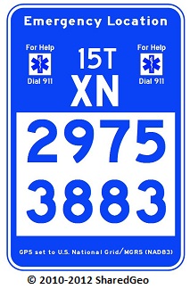
After years of testing and multiple sign prototypes, SharedGeo’s efforts, along with the efforts of other local and national advisors, led to creation of unique emergency location sign based on the USNG. Known as “Minnesota Markers”, these signs use the USNG coordinate system to denote geographic location in a way that can be accurately and efficiently reported in an emergency, thereby increasing the success of emergency response efforts. The signs are available as preprinted or blanks to allow local/field production, use a license-free font that mimics the Federal Highway Administration (FHWA) font, meet the FHWA color standard and the National Trail reflective standard, and use an eight-place USNG coordinate that is accurate to within 33′ when determining the location of an emergency.
For more information see Bob Basques and Steve Swazee’s USNG presentation (see presentation called: “U.S. National Grid Trail Markers – Bringing Geolocation to a Trail Near You” and the USNG Marker project page.

No comments