USNG in Action: Lake County, Minnesota

October 29, 2014 by central No Comments

As USNG Emergency Location Markers (ELMs) become increasingly prevalent on northern Minnesota trails, there has been an outpouring of support from the snowmobiling, cross-country skiing, and other outdoor recreational communities along with emergency responders.  But no one is as fervent of a supporter of the USNG ELMs as Lake County Emergency Manager, BJ Kohlstedt.

Ms. Kohlstedt was first introduced to the USNG ELMs when she was approached by SharedGeo Executive Director Steve Swazee and Technical Director Bob Basques in 2010 to partner in their OPERA grant-funded pilot program for the ELMs.  Having been asked by the local snowmobile club to install location markers along trails in the area, Ms. Kohlstedt and Lake County accepted the offer to partner with SharedGeo.

In October 2010, representatives from Lake, Cook, and St. Louis counties, the Department of Natural Resources, and the US Forest Service—among others—met with SharedGeo to design  a recreational sign that could be both universal and consistent with state and federal signage regulations.

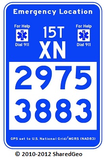
According to Kohlstedt, the first USNG signs were installed in Lake County in Fall 2012, with the first emergency response using the ELMs in January 2013:  “There was a lost skier out alone at night. She wasn’t from the area. She called nine-one-one and read the sign on the snowmobile trail, and the rescue guy knew exactly where she was.  She was only a two-minute walk from the road.”

Since then, the ELMs have been “spreading like mad to other counties and other states,” said Kohlstedt, and she has been working tirelessly to promote public awareness of the signs throughout her area.  Kohlstedt, along with other Lake County emergency workers, has spearheaded the creation of free USNG guides and brochures showing the locations of the signs on the trails,  and made them available at bars and restaurants along the trails.  Local bars also ask for their own USNG signs with their coordinates to be made, to display for their patrons.

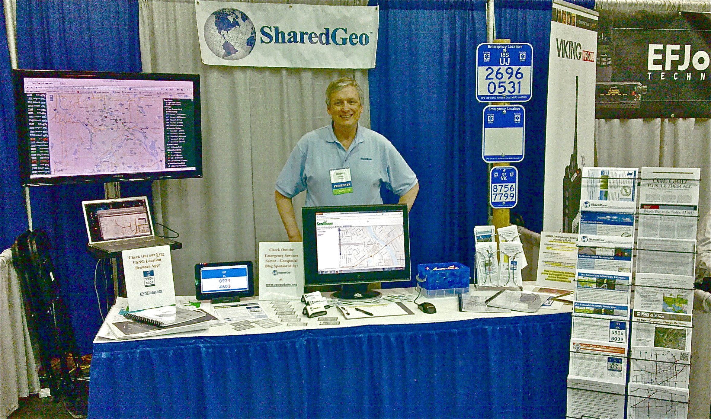
Kohlstedt also gives informational presentations about the USNG ELMs, where she often references SharedGeo’s USNG Information Center website as a resource for the public to go to download USNG apps, print their own ELMs, and get more detailed information. According to Kohlstedt, “the mobile USNG app is a crowd favorite.”

SharedGeo Goes to 2014 MN Interoperability Conference

June 8, 2014 by central No Comments

2014_0415_MN_Interoperability_Conference

Executive Director Steve Swazee mans the SharedGeo booth.

SharedGeo Executive Director, Steve Swazee, and Techincal Director, Bob Basques, were invited to attend the 2014 Minnesota Public Safety Interoperability Conference, which took place April 14-16 in St. Cloud, Minnesota. With technology’s role in public safety as the driving force behind the conference, SharedGeo fit right in, and Mr. Swazee and Mr. Basques were able to effectively showcase a variety of current projects.

SharedGeo’s big draws were Mr. Basques’s Automatic Vehicle Locating system (AVL) and the US National Grid (USNG) Minnesota Marker Project.  The SharedGeo booth, which experienced good traffic in the exhibitor hall, provided conference-goers with the opportunity to speak in-depth about the AVL and USNG projects with Mr. Swazee and Mr. Basques, as well as access to demonstrations and a wide selection of informational documents about SharedGeo projects.

The conference itself, which boasted around 250 tech savvy attendees with mainly radio and communications backgrounds, focused primarily on First Net, the public safety broadband network developed under the guidance of the U.S. Department of Commerce, National Telecommunications and Information Administration.

To learn more about the Minnesota Interoperability Conference, First Net, or SharedGeo’s AVL and USNG projects, please visit their websites.  And don’t forget to check out the new USNG Information Center for the more USNG news, tutorials, and technology.

GeoMOOSE Recognized by Governor Dayton

April 22, 2014 by central No Comments

geomooseMinnesota governor Mark Dayton formally recognized the GeoMOOSE team for their outstanding work on St. Paul’s GeoMoose-based mapping service and data management system, GISmo.  Read Governor Dayton Recognizes City GIS Team on the Spotlight on Saint Paul website for more on this story.


SharedGeo Goes to WLIA Conference

February 20, 2014 by central No Comments

Technical Director Bob Basques mans the SharedGeo booth.

Technical Director Bob Basques mans the SharedGeo booth.

SharedGeo Executive Director, Steve Swazee, and Technical Director, 
Bob Basques, each gave presentations at the 27th annual
 Wisconsin Land Information Association (WLIA) conference February 
12-14 at the Marriot Madison West in Middleton, Wisconsin.  The
 conference focused on making the vision of Wisconsin’s GIS future into 
a reality and served as a platform to showcase the latest open source 
technology–including SharedGeo’s shared funding project, GeoMOOSE.

Executive Director Steve Swazee presented SharedGeo’s Minnesota Marker
 Project: “U.S. National Grid Trail Markers — Bringing
 Geo-location to a Trail Near You!”  The presentation discussed the 
technical and practical considerations for deploying the USNG marker 
system, and the ways it enhances safety and emergency response in 
recreational areas, like parks and trails. Mr. Swazee also talked 
about how markers have been deployed in Minnesota’s
 Arrowhead region, and how the markers are being considered for
 statewide adoption by snowmobile clubs and other outdoor enthusiasts.

Technical Director Bob Basques’s presentation highlighted SharedGeo’s
 Automatic Vehicle Locating (AVL) system. Basques discussed how the AVL 
system was built using GeoMOOSE, OpenLayers web clients, Mapserver, 
and the PostgreSQL database, and why the team chose to build their own
 web viewer instead of a commercial package. Mr. Basques also 
demonstrated AVL production services in a live view mode.

Both workshops were well attended, and SharedGeo’s booth in the
 exhibition hall experienced heavy traffic with conference-goers 
expressing strong interest in SharedGeo’s open source software,
 GeoMOOSE, Mr. Basques’s AVL project, and the USNG Minnesota marker
 project. You can learn about GeoMOOSE, the AVL project, or the USNG 
Minnesota marker project and all our other projects on the SharedGeo
 website.

GeoMOOSE and City of St. Paul Win Governor’s Award

November 3, 2013 by central No Comments

SCN_20131014112840_001 copy

SharedGeo is pleased to announce that the locally developed, geospatial open source program, GeoMOOSE, was recently recognized with a Commendation from Minnesota’s Governor, Mark Dayton.  The award was presented to the City of St. Paul for its role in the creation and release of GeoMoose as an open source project.

Administered by the  Minnesota Geospatial Information Office (MnGeo), the Governor’s Award honors a project or organization that “exemplifies a commitment to coordinated, affordable, reliable and effective use of GIS to improve services within Minnesota” by improving government responsiveness, promoting public access to information, and fostering and exemplifying the benefits of collaboration.  The first version of GeoMOOSE was developed by SharedGeo Technical Director, Bob Basques, SharedGeo chief programmer, James Klassen, and Dan Little, of D.B. Spatial, while they were employed by the city of St. Paul.

GeoMOOSE joins Mapserver as one of only two open source programs honored with the Minnesota Governor’s Geospatial Commendation Award. Earlier this year, GeoMOOSE also joined Mapserver as one of only two open source programs with Minnesota origins to be officially sanctioned by the Open Source Geospatial Foundation (OSGeo).

As an open source software, GeoMOOSE is available at no-cost to any organization that would like to serve spatial data publicly. You can learn more about GeoMOOSE and the Minnesota Governor’s Geospatial Commendation Award by visiting the GeoMOOSE and MnGeo websites.

SharedGeo to Participate in 2013 Give to the Max Day

November 3, 2013 by central No Comments

giveMN_tag_RGB_for webSharedGeo is proud to be participating in GiveMN’s 2013 Give to the Max Day on November 14.  As an IRS approved 501 (c) 3 non profit, SharedGeo relies on support from our friends in the community to continue our work with the emergency services sector, our groundbreaking efforts with the US National Grid project, and to continue providing and developing free, open source GIS software for the public.  We hope you will consider donating to SharedGeo on November 14.  To schedule your donation for Give to the Max Day, click here.

SharedGeo Executive Director & USNG Featured in “Living Ready” Magazine

September 1, 2013 by central No Comments

SharedGeo Executive Director and U.S. National Grid proponent Steve Swazee was featured in the article “One Grid to Rule them All” by Brett Ortler in Living Ready magazine’s Fall 2013 issue.

The article provides a brief history of the U.S. National Grid system including examples of how using the U.S. National Grid can overcome problems encountered by emergency responders when using latitude and longitude.  The article goes on to explain how the grid works. Using the National Grid coordinates for the Minnesota State Capitol Building as an example, Ortler details how the coordinates are broken down into zone designations, regional codes, and local coordinates to provide the most precise location information possible. Ortler also discussed how the U.S. National Grid can be used with both electronic and paper maps.

Ortler cites the simplicity and versatility of the U.S. National Grid as the primary reasons to use the system, and he features SharedGeo’s Minnesota Marker Project as a real-life example of the Grid in action.  Though currently in trials, the Minnesota Marker Project has led to at least one rescue and is being used as the model for other Grid programs throughout the country.

You can read more about SharedGeo’s efforts with the Minnesota Marker Project under the Projects tab. Check out the Living Ready website to learn more about the magazine and “One Grid to Rule them All.”

SharedGeo Helps Local Girl Scouts Get the Most Out of Maps

August 2, 2013 by central No Comments

Cookie on the Go MapOne of the greatest challenges facing public, private, and nonprofit organizations alike is effectively and efficiently identifying potential clients, markets, and/or patrons directly related to the organization’s mission or business.  However, Geographic Information Systems (GIS) mapping technologies can greatly simplify this process by organizing data into easy to understand, customizable diagrams and maps.

The Girl Scouts of Minnesota and Wisconsin River Valleys have already put GIS mapping technologies to work for them with Cookies on the Go maps, which identify the best neighborhoods for selling cookies, based on which areas are without or have very few Girl Scouts.  Cookies on the Go maps, originally created by Alison Slaats with Envision Minnesota, break down census blocks and household density data into easy to understand selling-area maps tailored for use by individual Girl Scouts.  Slaats, who currently works at GIS nonprofit, SharedGeo, made over 1600 Cookies on the Go maps for the Girl Scouts of Minnesota and Wisconsin River Valleys in 2013.

With the success of the Cookies on the Go maps, the Girl Scouts of Minnesota and Wisconsin River Valleys have begun using GIS mapping technologies to identify potential new scouts and better serve the girls in their communities. “We have been using the spreadsheets and maps to identify girls within our jurisdiction, and the [spreadsheets and maps] have helped us identify where to focus our resources to better serve Girl Scouts in the community,” said Sara Ernst, Membership and Volunteer Services Director at the Girl Scouts of Minnesota and Wisconsin River Valleys.

The Enrollment Potential project, created by Slaats with SharedGeo, uses demographic information from the Minnesota, Wisconsin, and Iowa Departments of Education to identify which communities are being underserved by the Girl Scout organization. The resulting spreadsheets and maps are arranged by service unit area, showing the number of girls in each school in 49 counties, then organizing this data by age and Girl Scout level.  According to Ms. Ernst, the GIS maps are useful for staff and volunteers to be able to know where girls are, so that they can better target resources to schools and communities without troops, know where troop leaders are needed, and where potential new troops can be formed.

As is demonstrated by the Cookies on the Go and Enrollment Potential maps, GIS mapping technologies can be used to fit a variety of needs. And, because most GIS projects are custom-built, the ability to apply mapping technologies to inform projects or processes is nearly boundless. Whether you need to find potential new clients or communities to serve, or just need to identify the best neighborhoods to sell cookies, using GIS mapping technologies is the smart, cost-effective, and user-friendly way to unlocking your organization’s data potential.

SharedGeo Goes to FOSS4G-NA

June 17, 2013 by central No Comments

FOSS4G-NASharedGeo was a sponsor and exhibitor at the 2013 Free and Open Source Software 
for Geospatial
 North America Conference (FOSS4G-NA), which took place May 22 through May 24 at the Minneapolis Marriott City Center and was attended by nearly 400 people. SharedGeo Executive Director, Steve Swazee, and Technical Director, Bob Basques, shared and discussed SharedGeo’s wide range of capabilities, products, services and projects with FOSS4G-NA attendees.

FOSS4G_Booth_Small copy

Mr. Swazee introduced enthusiastic FOSS4G-NA conference-goers to SharedGeo’s many ongoing projects, like the U.S. National Grid Emergency Marker project (USNG), and distributed fliers about SharedGeo and the Director’s Blog.  Mr. Basques engaged attendees with technical and coding information about SharedGeo’s variety of open-source software products, while showing demonstrations of 3D Maps in browsers and videos of drone flights. Mr. Basques and Cory Karsten also delivered a well-attended presentation about their Automatic Vehicle Location (AVL) implementation efforts in the City of St. Paul.

SharedGeo Administrative Director, Nancy Read, also played a key role at FOSS4G-NA by leading SharedGeo’s role of fiscal agent for the conference.   In addition, Dr. Read presented with Brian Fischer of Houston Engineering on the open source suite of software being used at the Metropolitan Mosquito Control District.  Dr. Read and Mr. Basques—along with representatives from the DNR, Portland TriMet, and AppGeo—also served as panelists for a discussion on the use of open-source software for state and local governments.

One-Dollar Bitner-Small copySharedGeo was also represented by Chief Programmer and Technology Developer, Jim Klassen, who served on a panel of experts that discussed the merits of various geo-portals.  Mr. Klassen also met with GeoMOOSE coders for a code sprint on the final day of the conference.

The success of the FOSS4G-NA 2013 was due in large part to the leadership of David Bitner, owner of dbSpatial LLC, along with a team of dedicated volunteers.

SharedGeo Featured in St. Paul Pioneer Press

May 14, 2013 by central No Comments

SharedGeo and the US National Grid (USNG) Emergency Markers Project were featured in the May 12th issue of the St. Paul Pioneer Press.  The article, written by Pioneer Press tech writer Julio Ojeda-Zapata, discussed SharedGeo’s role in the inception of the Marker Project and how the marker designs have evolved over years of trial-and-error.

The article also detailed how the markers help emergency responders locate emergencies, using real-life stories of people whose lives were saved because of the USNG markers.  Mr. Ojeda-Zapata discussed the future of the Marker Project, and the distinct possibility of the markers being implemented on a national scale.  So far, the markers are being tested in Minnesota’s Arrowhead region.

SharedGeo Executive Director, Steve Swazee, and Technical Director, Bob Basques, were interviewed for the Pioneer Press’s piece entitled, “Minnesota Marker Signs Might Look Funny—Until You’re Lost and Need One.”  Check out Julio Ojeda-Zapata’s blog for more on the Marker Project.